Tuesday 29 April 2014

Dinosaurs and Salt Lakes - posted from Boise, Idaho

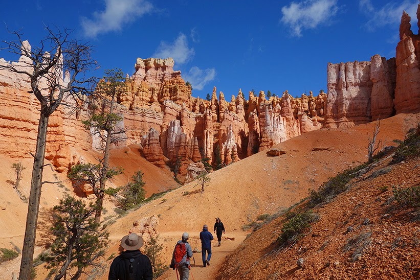
A lot of National Parks are located in the area I traveled the last few weeks. Now, however, distances between destinations are getting larger, so there will be more driving and less sightseeing in the coming posts (which means that there will just be fewer posts, but covering the interesting stuff).
First of all, let me stress that the blog posts that are published are about a week to a week and a half behind on where I currently am. This makes publishing a little easier, because there sometimes is no internet connection available, as well as that it takes time to put a post together, which, sometimes, is just not there on the same day. Nowadays I take an 'off-day' once every few days. This means not driving and sightseeing all day (at the max half a day), but instead sitting behind the computer and updating finances, shopping for groceries, selecting and updating pictures, editing or uploading video, answering e-mail... etc. Quite relaxing and nice to get the updates on how the home front is doing as well!
To make this a little more understandable: the dates and locations on the picasa albums are always matched to the dates and places the pictures were taken. With regard to the blog post the location is the location that the post is about, and the date the post is published has nothing to do with when the actual events took place. I'll include the place where I published the blog post from in the title for the coming few posts to at least give you an easier indication of where I'm currently at. The route map that is sometimes included also shows the latest info as to where I am and where I've slept:

The story of who the Blacks are, and why I have spent 4 nights in the Boise area will have to wait for a couple of days, because this blog post will talk about Dinosaur and the area around Salt Lake City.
The last post ended with my motel stay in Grand Junction... where I cut my hair again after a couple of weeks (it needs another cut now), got a good shower, shave and my 'off-day' because the check-out time was 12:00 am. 12:00 am is noon, and 2 am is in the middle of the night, which I of course knew, but sometimes you get sleepy and call your parents thinking that it's 14:00 at their place... 

Anyway: a long drive up to Dinosaur national monument: 140 miles to be exact. Nothing much exciting, farming lands with sometimes beautiful hills and mountains in the background. one cool pass to drive up through, but for the rest a lot of nothingness. A few pics of the drive are on Picasa. I arrived at Dinosaur national monument at about 14:30 (canyon entrance), but the visitor center there was closed. The park consists of an exhibit hall where a huge fossil find has been preserved the way it was found, and an inaccessible Green River Canyon. I had planned on maybe visiting the canyon a little bit (to get some nice views), but since the visitor center was closed I could get no info on how far it would be to really get into the place. The campsites were also closed, so I would have to stay outside of the park for camping... so instead of heading into the canyon I went west, where the separate entrance to the quarry exhibit is.
Another surprise here: the quarry is only accessible on a guided tour, which leaves every few hours. Based on the material I had read I had assumed you could just visit it during opening hours. Luckily I was on time to make it to the last tour of the day pfew(!). There was even some time to watch a movie on the history of the park: the canyon goes on the one-day todo list: another beautiful but inaccessible place. The geology of the place has caused a number of very old rocks to be upturned and lifted up to the surface: the reason why the dinosaurs could be found here.
The quarry itself was quite impressive, a huge jumble of bones and various dinosaur parts. Especially when you imagine that the scale of this display is only a small piece of the total find (of which a lot of bones are now on display at the Smithsonian).


All these bones are in sedimentary rock, meaning that this was probably a slower moving part of a river, where a lot (really a lot) of dead dinosaurs (and pieces of dinosaurs) flowed to and were covered in mud. An interesting thing to see, and also nice to talk to the park ranger about the history of the place and work as a park ranger. More pictures are on Picasa.
The tour ended at about 17:00, and I had planned on staying at a free campsite near a lake a little while down the road (a 2 hour drive on). Getting there at dusk I got another surprise: a 20$ camping fee instead of a free campground! 20$ for a toilet is a little too nonsensical for me, so I opted on driving on and finding a place on the side of the road. After a few turn-offs which did not deliver anything useful (ending up between trailerparks) it was getting darker an darker. But ofcourse luck helped and I found a nice spot just outside a nature reserve. I couldn't see it at night, I could only hear the geese and see that there was hardly any civilization around (lights in the distance). The next morning it became apparent that my luck had landed me in a place with a beautiful view.


No time to enjoy this anymore than breakfast and toothbrushing because I need to get to Salt Lake City! Lots and lots of driving again, but this time it looked as if I was driving into the arctic! A lake miles wide frozen over and covered in snow... mountain passes with snow on both sides going higher and higher... I was getting worried if I would have enough warm clothes with me!


After a high mountain pass I got a nice view of the valley in which Salt Lake City sits. Once I got into the city it became apparent that here it was spring, or even 'rokjesdag'. Trees were blossoming, people were smiling and wearing skirts and shorts, probably spring had just arrived. With my double layered, longsleeve clothing I soon got very warm, so time to change into spring mode as well :-). It was actually quite strange to be driving in heavy city traffic again after a lot of no-traffic backroads and no-people campsites.
First destination in Salt Lake City (SLC) was the Natural History museum. We had been talking about dinosaurs with Tyler's family, and they told me they had just been there and that I would have to go and see it when I was in SLC. 
It definitely was one of the better musea. Not only for the dinosaurs (with a lot of them being found in the places where I had been to in Utah), but also for explanations on geology, which I had been wondering about driving through all of the different landscapes.


The museum itself is an architectural masterpiece. It is designed around one route through the whole museum, offering views of SLC and the valley when the exhibits in the route were also about that. A number of displays in the museum featured multi-story display cases with a lot of different objects showing the diversity of history, geology and culture in the area. Definitely a must-visit when you are in SLC. 
There was a temporary exhibit on chocolate, showing where the natives traded this 'royal drink' before the Spanish started trading it with the rest of the world. Of course the whole purpose of the display was to get people to buy chocolate in the shop at the end of it (spraying chocolate sent in the display area really awakens a lot of neurons that start screaming for chocolate). I resisted.
The museum also featured minerals and crystals in the most crazy shapes and colors: amazing stuff. 


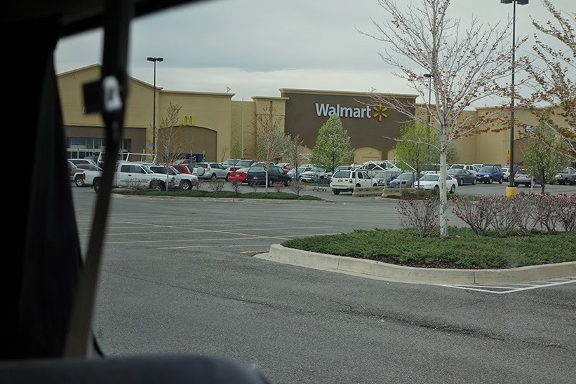
After the visit to the museum it was time to get some groceries, find out if there was anything interesting going on in SLC and find a place to stay. I combined the first and last of these two by opting for an all American experience: camping on the Walmart parking lot. Walmart is a 24/7 store with guarded parking lots. They want their customers to shop at their places, so they offer people in RV's to park and camp on their parking lots (ofcourse the idea is that you get your supplies and maybe breakfast at their place). This idea didn't seem all to appealing to me, but of course you have to try everything once! The first Walmart I thought of camping at was full of hobo's and had no other campers... this didn't seem like such a good place so I checked another (there's like 5 or 6 huge stores in SLC). This one had other campers and a little more remote corner where you are not directly in the shopping traffic. The parks lighting stayed on all night, but my curtains kept it nice and dark inside the van. I woke up to the noises of some doubtful people talking (and trading?) in the middle of the parking lot at 03:00am, but I could get to sleep again quite quickly.

A different view to wake up to then I was used to...

The plan for my day in Salt Lake City was to have a look at the center of the Mormon world, another look at crazies at the Comic con which happened to be this weekend, and to end the day with a drive to the Bonneville proving grounds on the salt flats west of SLC. An impression in pictures below:


The Mormon temples looked very 'netjes' as did the people visiting them. There were a lot of people getting married and having their pictures taken on the grounds as well. The whole setting reminded me of the 'Flanders' family from Southpark. Very busy with keeping up appearances and conforming to the norms set out by the Mormon church. I read a little of the displays there, but did not have time to really get into the details. Apparently some guy in the 1800's had a 'revelation' that he was the new chosen prophet to find a promised land in the US. He even got new stone tables with holy books from the lord! He managed to convince a lot of people of his story and founded SLC as the Zion of his religion... I'll have to read up on the story, but the guy got killed by the government and has been a holy martyr for his people ever since. To me it sounds like a very good way to get a lot of power over a lot of gullible people... but apparently the organization is still very alive today with a lot of Utahns being LDS or member of the church of Latter Day Saints.


Comic con was a good balancing act for all the 'keeping up appearances' crazies of the mormon Church. It is a conference for fans of television series or films, or just nerds in general. These people are not too scared to show they're crazy, just like the rest of us, so they dress up as their favorite characters... the streets were filled with Dark Vaders, Wookies, Super hero's and zombies. 


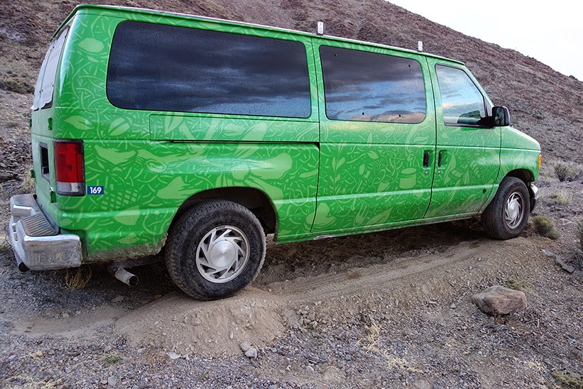
Ok, enough crazies for me, off to the Salt Flats. If you know what this place is all about: see the movie 'the world's fastest Indian'. It is about a New Zealand guy dreaming of racing his motorcycle here and setting a world record. Some overlap with my travels, so nice to be able to go to this place. Of course I had to 'don't be gentle it's a rental' on my van here... so an impression below.


It was very early in the season so the flats were still kind of wet. I asked around at a local fuel station about conditions, and someone had got stuck a couple of weeks ago. Drive on the tracks that other people have made (and look hard) and I should be alright. Let's try.... ah it's nice and slippery indeed :-D


All guidebooks warn on getting the mud of your vehicle immediately as it is very corrosive. They mention that local fuel stations offer hoses to do this as a service. However, the station I was at did not do this and said that I should go to a car wash in the local town (which is not the way I was headed)... grrr. Well... time to camp so this'll have to wait till tomorrow.


I didn't feel like camping at Walmart again (even though I would have to get back to SLC the next day), so I opted for a local dirt road behind the salt flats. I was looking for the endless Salt Flat view. The drive didn't have too many turn outs, but at one place there was a track heading into the hills which looked accessible. I had too first clear the shoulders of the road though, so that I could get over with my small clearance vehicle :-D. Driving up the track onto the hill I kept looking for a horizontal spot to park the car... this didn't come, and didn't come, and didn't come, until the track was getting too steep for my 2 wheel rear drive vehicle... There was small knoll nearby, so if Mohamed couldn't get to the mountain, the mountain would have to come to Mohamed.... I opted for some civil engineering hand work and dug up the slope until my vehicle was at such an angle that I would be able to sleep :-D.


Dinner tasted very well after this hard work, and once again I had found a campsite with an amazing view. In the next post: a small hike in this area and the (boring and long) road to Yellowstone.

Day 26: Grand Junction, Dinosaur and the road to Salt Lake City
Day 27: Salt Lake City
Day 28: Salt Lake City and Bonneville Salt Flats

Monday 28 April 2014

Moab! (2/2)


Let's start with something I forgot to do last time: post a route update. I've added quite a few miles since last time! The counter is already at 4700 miles or about 7500km! I've paid for 6000, so that means I'll probably have to pay extra by the time I get to LA (the trip into Arizona wasn't planned, and my overall planning was a little too conservative). Ah well, it's definitely worth it!


So, back to Moab! After the great hiking in Canyonlands we camped at BLM's Horsethief campground. When choosing a site we had explored the grounds thoroughly to find one with good orientation with in relation to the wind (which was blasting cold) as the campground is near the top of a hill. We maneuvered the van in such a way that it would block the wind from the table which would double up as Tyler's shelter. 
After that it was the usual: get the fire started, cook a meal, clean up the dishes and get read for sleep. Tyler had been a bit restless during the day and announced that instead of going to Salt Lake he would go back home. This triggered a good discussion about his reasons and how he's been living for the last couple of months. 
The next morning I dropped him off at Moab, from where he wanted to start hitchhiking back. I'm glad I met him and I think we had a great week exploring the US together. It was also great fun to meet a few of his relatives and friends to get a glimpse of the real day to day US life. Tyler: all the best, and I'm curious what kind of business you'll be running in a couple of years ;-)

For me the travel continued: I got the van's supplies restocked and headed off for Arches National Monument. I decided to head for the furthest arches and hike first, and let the schedule decide which other arches to visit on the way back out of the park. 
The hike would consist of a visit to Landscape arch, and time permitting, a walk on 'primitive loop'. However, judging by the schedule posted by the Park I thought time would not allow me to complete this loop. The landscape this trails winds through was once again stunning: an alien landscape consisting of a wind-eroded labyrinth of huge ridges.


Hidden in between these ridges were various arches, some of which on the brink of collapse. That's why you can no longer walk below the top one below.


The hike was actually quite exciting, and once again physically challenging (height and soft sand combined with my devilish pace). When I needed a break I first climbed a nearby cliff or ridge, so that while resting I could enjoy the great views. At the start of the hike there were signs saying that you should go prepared and take water, food, clothes for inclement weather and a map. I didn't take the last two, and was timing my hike so that I could be back in time to see a little of the rest of the park and also get some miles on the road. This meant that by the time I got to 'private arch' (the above picture) I took one last break, and would then have to turn back. 
At the start of the trail I studied the map of the hike: it featured one trail leading up to the loop track. On the track I came across a German couple who looked rather exhausted. I had a chat with them about how far they went and whether the stuff they saw was worth it. They said it was very beautiful, but that they had had a very difficult time getting back to the parking lot (they hadn't known that the rocks piled on top of each other indicated the route). When I had about 5 minutes left on my schedule I came across a three way sign: indicating 'primitive loop' left and right, and 'private arch' straight on. I wanted to see the arch, was sure I had no time left to start on the loop right now, so I headed on to ask the first people to meet me on the private arch track how far I still had to go. Luckily the answer was about 100ft, so I made it to private arch!
I walked to the end of the cliff that private arch is on to enjoy a great private view into an alien landscape for a couple of minutes (the picture once again does not do justice to the scale, find the trail to get an idea of how large this valley is).


Because I didn't feel like hiking back the exact same trail I squeezed myself through a nearby rock crack to see if I could get down into this valley. The tracks seemed to indicate that there had been people hiking there, and it also looked like a great shortcut (the track I had come from had looped and zigzagged across multiple ridges to the one where this picture was taken). It took some squeezing and climbing for about 100m, but then I ended up on an isolated platform, with a 7m vertical drop to get to the bottom of the valley. No ropes, so no option to try this :-(. If you look at the above picture on picasa, you can see some people walking on the top middle ridge. I had been studying these to see if they were going only one way, because I couldn't imagine that the loop track would go away so far and return to the point 100m behind me. However, people were walking on it in both directions, so I concluded that it was another trail with a dead end and started back on the trail I had come.
Near the beginning of the track there were two turn-off to see some Arches. You can see these in the pictures on Picasa. When I got back to the start of the track I studied the map that was posted there carefully and started cursing myself a little...


Private arch was already 2/3 of the way on the primitive loop! A guy who I had met on the trail earlier was standing nearby and told me that the Devils garden part of the trail was the most incredible he had ever seen (that was the ridge in the above picture), adding to the pain... well, another lesson learned (Bring the frigging map!) and I guess I'll have to come back here some day and walk the proper loop.

Now with a little less haste as in the way coming into the park I drove the way back to the park entrance slowly to enjoy the views and get out wherever there were interesting formations. Some impressions below:

Delicate arch from a distance


I skipped on delicate arch because I didn't have time to do the full hike and also because it is 'the most photographed piece of geology on the planet'. You can see on the full-res picture on Picasa that there's about a 100 people standing around and under it. Actually I enjoyed the stunning rock cliffs in the bottom picture more than the arches: what great scenery to drive through!

The next destination would be Dinosaur National Monument, about 200 miles north of my current location, so way too far for the 1-2 hours driving time I had left in the day. Furthermore it was time to get my hair trimmed and my beard shaved and I was craving for some luxury... Checking the rates for Motels in Moab offered no solutions (everything was fully booked due to the 4WD event, and prices were $ 120+). However, in Grand Junction a motel went for about $ 30 and it was on the way to Dinosaur via the 128 scenic route along the Colorado river. I plugged the coordinates into the GPS unit and went off.

The drive through the Colorado canyon was once again stunning: very little traffic and great views of the river and the canyon.


Inside the canyon were some greatly situated Ranches... nice places to stay if you're ever in the area. When emerging out of the canyon it was broad views into the desert distance again. Here and there were chemical plants, or deserted towns.


A final piece of highway driving and then it was personal grooming time at the Motel in Grand Junction... and a nice relaxing sleep in a large bed in a heated room.... :-D.

A lot of driving and a visit to Dinosaur National Monument in the next post!

Day 25: Moab Arches

Thursday 24 April 2014

Moab! (1/2)

The last blog post described our arrival in Moab, so let's continue from there on.
Recap: We got some information from the local tourist info and checked online for 'free' camping. A few sites were recommended, but Kane Creek Canyon was the closest one, so that's where we headed.

It started out as a muddy creek, with the first camping also being a muddy flat full of red-neck looking RV's. Not too promising! The sites are managed (everything in the US seems to need management) by the Bureau of Land Management (BLM). These guys had also put up a sign with a map of the other camping sites in the canyon, and this showed that we had three more options down the route: so we continue on.
The second camping site looked quite nice, but was full and had no vehicle sites, the third one was full, but looked beautiful (inside a little side canyon)... so it would have to be the fourth one...
Yes! An OK looking area, with 2/4 vehicle sites still unoccupied. We put up a sign on site 1, so that we could check it out without someone else taking it. By the time we went to explore site 2 there were people there that just moved in, so we were lucky that we 'pre-booked' nr 1. It's a site between the road and a little stream, with a 30m vertical red stone cliff on the opposite side of the stream. We were exploring what the best site would be to build a shelter for Tyler when I spotted an overhang on the opposite bank. There were stepping stones in the stream, so we went and checked it out.
This overhang was THE perfect site: a stone platform about 50cm off the ground, varying in width from 1-3m, with a rock ceiling jutting out about 3-5m, some 2-3m from the ground. As it was starting to rain, we immediately started moving camping gear to this place: we would cook here, build a fire there (we moved the fire ring), and Tyler would build a little shelter within the natural shelter to sleep.

The overhang under which Tyler camped. The stream is visible in the lower right.

We got set up quite quickly, the meal was great, and we were enjoying the huge shadows that our campfire was casting of ourselves on the vertical rock above us. We were warm and dry while the wind was howling and it was raining outside... some of the other campers must have been a little jealous.
Previous experience in Iceland had taught me that rain and wind in a little tent will prevent you from sleeping (flapping tent fabric, lots of noise)... so we were looking forward to a good night of sleep, me in the van, and Tyler in his natural shelter. The only thing we were worried about was if the stream would not overflow with all the rain. And of course Cougars and Coyote's are always on the worry list, but I thought Tyler should be fine with a fire right in front of him, and natural walls all around.
Let me tell you that neither slept very well that night. It started at about 02:00 am when I heard something scratching the van. I woke up, got my light and started shining it around the van trying to find out what the hell was going on. However, I couldn't spot any wildlife outside... so after some watching in the dark I closed the curtains again and tried to get back to sleep. About a minute later I heard something rustling in the trash bag. I picked it up and shook it but nothing made a sound anymore... wtf. We bought firewood that afternoon that came in a large cardboard box so thinking that there might have been a mouse nest in it I checked it... nothing again. We had a bucket full of kindling wood from Byron, but that had been in the van for a couple of days already, so if something was in that bucket it would've woken me up a lot earlier.
Grrr... no other option but to sit back with a headlamp on, hold still and wait for the sound to start again.
A couple of minutes later I heard something rustle again. I quietly turned out the light, and there was a little mouse, gnawing on the bottom of the thrash bag.... let the hunting begin!
First of all I got all the food wrapped in soft plastic off the floor: so imagine the van with a thrash bag tied to the ceiling, and on the other side a bread tied to the ceiling...
Within my foodstock were some peanuts and pasta, and empty one gallon water containers (used to refill the water tank). I dropped some peanuts and pasta in the water containers and put them up vertically, in the hope the mouse would go in and not be able to come out again. After this operation I held still again and turned the light off (it was now 02:30).
After a little while, the mouse appeared. Right on my bed, about 30cm away... it hopped about a little bit and I could see it catch the scent of the peanuts... into the food stock area it went... climbing around a little, sitting on the ridge of the water container, but not going in.... checking the other water container... same story... hopped off towards the thrash bag... can't reach it anymore... back to the water container. This time when it is putting its snout in the container I give it a little push, and catch it! Ha Ha! It starts jumping frenetically to try to get out of the container, but I put my hand on it to prevent it from doing so. A quick picture, and off with you into the night: I set the mouse free from the passenger side of the van and get back to sleep.


Some 5 minutes later I hear something scramble up in the engine compartment... 1 minute later mister mouse is out and about again, now trying to chew through the plastic of the peanut bag... aaargh (03:00am by now).
Betting that the mouse won't fall for the same ploy again it's lights on and trap building time! I build a noose around the water tap and put a peanut inside it. The first time the mouse doesn't put his head in far enough when I pull and he's gone before the noose gets him. The second time he rans off with the peanut and the noose doesn't get him. The third time he gets to close to me (5cm) that out of pure frustration I try to get him by hand, but he is too fast for me.
By this time Tyler drops by to see why my lights are on. He has a story of not being able to sleep himself as well. He says someone was throwing rocks to him and that someone was by the van and near to his sleeping site as well. I don't believe anything of it, but we'll see tomorrow. Tyler goes back to sleep again, and I tell him that I will as well, if I can catch the bloody mouse!
AFter the noose not working I put my engineering skills to use. I employ three different trap designs: a double sided ducktape area with a peanut in the middle (apparently Albert Heijn employed glue plates), a horizontal water container with a pull string to pull it upright when the mouse goes inside, and the old box with lid propped up with a stick on a string.
By the time I have everything finished it is 03:30-04:00. The mouse hasn't been scared by his last capture and my attempts with the noose because once I turn the light off I can hear him scrambling around again quickly. When I turn my headlamp on the ducktape peanut is already gone... so far for ducttape's one-fix-for-all usefulness. The mouse still hangs around the vertical water container, but won't put his head in anymore (I can study him from very close by as he is not scared at all). The finally he walks into the box and I just slam it's lid on by hand, ducktape the whole thing shut and try to go to sleep. This didn't go very well, because the mouse is scrambling and gnawing to get out of the box. After a time however he settles down and I can finally get some sleep (probably 04:30).
After a bad night we both felt kinda groggy, but we had to get up early and go to work on exploring the area. Breakfast, setting the mouse free (this time on the other side of the river), and driving off towards the first site: a petroglyph rock. You can see the drive and rock in the video below (and a little fun at the end). The rock is the on we stop at halfway down the video. You can see that the shadow covers it when we arrive, but that it is almost fully lit when we leave.


Sadly there was no Park Ranger Docent here, so it was guessing at what the petroglyphs meant. As you can see in the video we came across a lot of 4WD vehicles. The people told us that this week is actually an annual event in Moab, with 4WD driving courses all around the area (and lots of people). So that's why we saw so many 4WD drive vehicles on trailers on the highway... we spot a few more at quite a gnarly angled track above us down the road.


First plan: get to an official camping site near Canyonland some 20 miles north of Moab (claim it before noon). Check. Second on the list: groceries... aargh back to Moab again, should've done this first! That's what you get for sleepless nights... stupid mouse! Afterwards: quickly back to canyonland to check it out (I have no idea, except that I should go there). There's a few viewpoints where you can get to by car, and an interesting hike near 'upheaval dome'. Due to the limited time we have by now we decide to head for the furthest viewpoint first and than do the rest depending on how much time is left.
The first awe-inspiring viewpoint changes this however, and we get out to shoot some pictures first anyway.


The views here impress me more than the Grand Canyon, probably because here you can imagine the scale a little... grand canyon is such a unique site that you just don't have any reference for it. We drive all the way to Grand View Point and enjoy the magnificent view there. We hike all the way to the endpoint of 'Island in the Sky', just because we are enjoying the surroundings so much. Some pictures here, a lot on Picasa. We decide to run back, instead of walking, so we both (me a little more) end up completely exhausted when we reach the van.


We end the day by driving down the other viewpoints. By the time we reach upheaval dome it is nearly sunset. Since it is a picnic area we first cook some soup to have dinner and recover before hiking again. Very refreshing food so readily refuelled we hike up to upheaval dome. It is called that way because there is a strange type of rock in the middle of a crater, of which the geological origin has not been determined. It could've been caused by a salt rock layer melting away or by an astroid, the scientists aren't agreed yet. It makes for some beautiful pictures again though, especially with the sunset going on.


The plan was to also include the other Moab National Park in this post, but since it is already this long, I'll call it quits here and show you Arches in the next post.

Day 24: Moab Canyonlands

Tuesday 22 April 2014

Tyler's family and Bryce

After our magnificent hike in Zion we drove to Tyler's hometown: St George. We stayed at his cousin Sonny's house. He lives there with his wife Marina and daughter Mia and has two guest bedrooms. Sonny had to work really late (he works in road construction) because a piece of road had to be finished before the weekend (it later became clear it was one of the road reconstructions that caused us delays ;-)). Sadly we could only chat for a little bit because he would have to get back to work again on Saturday morning (working long, long days). Mia, their little daughter was fun to have around, she first thought I was a robber because I used my english name Robert to introduce myself. It took some convincing to get her to think otherwise :-).
Saturday was a slow day for us. We did the laundry, recovered from the hike in Zion. I had another laptop to fix, pictures to upload and blog posts to write. We did some grocery shopping and by the end of the afternoon Tyler showed me around St George a little. We went to Dixie rock, a local viewpoint where a lot of family's were hiking around and barbecuing. Nice to climb a little and enjoy the nice views of the city (Tyler pointed out places where he had lived).


Afterwards he showed me the local paintball court (he does quite well in competitions), and we went to a nice nature area (Snow Canyon). We had no time to really explore it (entrance fee required), so instead I just drove up to a viewpoint, which actually had a very nice view of it, which Tyler did not know yet (there are a lot of lava fields from a volcano eruption years ago).
We wanted to be back in time to catch some time to chat with Sonny, but when we came back Tyler's Grandmother was actually there. Marina told us that Sonny would be late again, but Tyler had been telling me about the frybread that his grandmother makes (the best there is), and she offered to make us some. See below to learn how that is done.


We had a nice meal of frybread with taco filling by the time Sonny was home and it ended up a very nice evening chatting with everyone in the family. And indeed, the frybread was the best I've ever tasted!

Next morning it was time to leave: the family had to go to a kite festival to celebrate Mia's reading accomplishments and Tyler and I had to get to Bryce. Bryce is something else all together. It is a place where rock colors and erosion have created a surreal landscape of pillars (called hoodoo's), canyons, arches, trees and cliffs. Words do not suffice to describe it, so I shall drop a few pictures here, but please check out the large galery on Picasa if you want to get an idea of what Bryce is like.

The black dots on the cliff on the right are people

Almost at 9100ft, a US height record for me so far


The first day we used the car to drive along all the different viewpoints, which was quite a drive. Ofcourse sometimes we got out and hiked a small way to a viewpoint, but it was mostly driving, all the way to the heighest point at 9100ft above sea level. We planned on doing a hike in the canyon the next day, but before that Tyler had a little 'hat hunting' thing going on. He didn't have anything to cover his head with at Zion, which, after all the sweating, convinced him that he would need something. At Bryce he spotted a hat down a little chute someone had left behind (wisely, because it was a large drop down the cliff if you slipped and fell). Ofcourse Tyler had to get and get it. 


He actually got two baseball caps for the effort of getting one. However, what he really wanted was a full hat (to be continued). By the time we started our drive back to the campsite (we got a camp site on the park's campgrounds when we entered) it was getting towards dusk. This is the time the local wildlife gets out, and we spotted two groups of deer along the way.


By the time we got to the campsite it was nearly dark, so I prepared a meal really fast, while Tyler got his camping gear out. We wanted to go to an astronomy and star watching evening at the visiotr center, so we rushed cooking, eating, and getting more warmly dressed. Five minutes before it would start we rushed off to the visitor center. Once there we found a ranger in front of a fence, telling us that the visitor center would soon be closing and that there was only this reading going on which would end very soon. We were like wtf?! Chatting a little more exposed the problem: Bryce is on Mountain time, just as the Navajo reservation but not the rest of Arizona :-(. -1 for Tyler and his local knowledge ;-).
We went back to the campsite and got ready for the night, which had come one hour sooner than we had expected. For Tyler's campsite we positioned the table in such a way that it would block the wind and be close to the fire, with my poncho draped across it to make a wind shield. 


The next morning we woke up to discover snow! However, the tent worked and Tyler actually got some sleep. We dressed very warmly because we wanted to do the hike in Bryce Canyon. When we showed up at the canyon the sun was out, and once we got into the canyon and out of the wind it was waaaaay too warm. The canyon itself looks very nice though, with the sun really getting the colors of the rocks to pop out. Once we're about half a mile onto the track, Tyler spots another hat, and this time the one he really wants. It is located on a very steep chute though, with no way down (except a sheer drop). After some deliberation, and me declaring him nuts, he jumps in when there's no other tourists around and grabs the hat. His first attempt at scrambling back up fails however... There are already some people coming by and asking if everything is alright... Tyler takes his shoes off and attempts another time. This time he makes it halfway up, and with a hand from me he makes it out of the chute.... crazy adventures but he has the hat he wanted (and for free!).

The walk itself is amazing again. Now you're right in the middle of all the crazy shapes and colors, and each turn has new surprises to it. You also get a much better sense of scale of the canyon. There were warnings about Cougars and other wildlife inside the canyon, and once you start walking around in it, you really get a sense of how big it is and how many hiding places there are: we even spot a deer inside the canyon! Again, I will add some pictures here, but please check out Picasa for the full set.


Note the 'new' hat

When we get out of the canyon the weather turns: it is snowing and a little while after also hailing: this is turning into a storm! We have to get into the car to get to Moab, so this is not that much of a problem (as long as the weather is better in Moab). Along the way it gets worse and worse however...


At Moab itself however the skies were blue again. I checked internet for recommendations on local campsites and found some nice roads to check out. Kane Creek Canyon looked most promising, but more about the campsite we found there in the next post.


Picasa links:
Day 21: St George
Day 22: (Road to) Bryce
Day 23: Bryce hike and road to Moab